
Èze topographic map
Interactive map
Click on the map to display elevation.
About this map
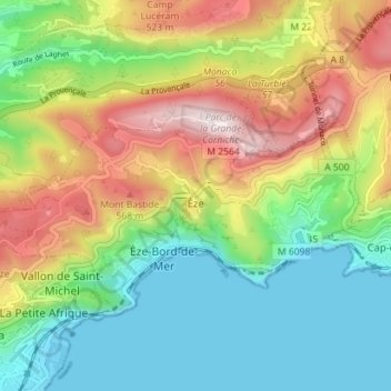
Name: Èze topographic map, elevation, terrain.
Average elevation: 261 m
Minimum elevation: -1 m
Maximum elevation: 699 m
Other topographic maps
Click on a map to view its topography, its elevation and its terrain.
Col de Turini
France > Provence-Alpes-Côte d'Azur > Maritime Alps > Moulinet
Average elevation: 1,549 m
Sainte-Claire
France > Provence-Alpes-Côte d'Azur > Maritime Alps > Guillaumes
Average elevation: 1,063 m
La Madone
France > Provence-Alpes-Côte d'Azur > Maritime Alps > Saint-Martin-Vésubie
Average elevation: 1,151 m
Mont Agel
France > Provence-Alpes-Côte d'Azur > Maritime Alps > Peille
Mont Agel is a mountain on the border between France and Monaco. The summit of this mount, at 1,148 metres (3,766 ft) above sea level, is on the French side, but the highest point of Monaco, lying on a pathway named Chemin des Révoires, is on its slopes, at an altitude of 161 metres (528 feet).
Average elevation: 790 m
Réca Véssas
France > Provence-Alpes-Côte d'Azur > Maritime Alps > Clans > Bancairon
Average elevation: 625 m
Cime de la Bonette
France > Provence-Alpes-Côte d'Azur > Maritime Alps > Saint-Dalmas-le-Selvage
Average elevation: 2,512 m