
Vale Pond topographic map
Interactive map
Click on the map to display elevation.
About this map
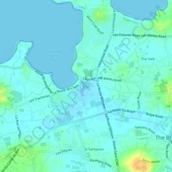
Name: Vale Pond topographic map, elevation, terrain.
Average elevation: 5 m
Minimum elevation: -2 m
Maximum elevation: 30 m
Other topographic maps
Click on a map to view its topography, its elevation and its terrain.
Saint Peter Port
Guernsey > Guernsey > Saint Peter Port
Saint Peter Port, Guernsey, GY1, Guernsey
Average elevation: 23 m
Petit Bôt
Guernsey > Guernsey > Saint Peter Port
Petit Bôt, Cliff Path, Saint Peter Port, Guernsey, GY1, Guernsey
Average elevation: 55 m