
Lehighton topographic map
Click on the map to display elevation.
Lehighton
Lehighton is located in southern Carbon County at 40°49′55″N 75°42′53″W / 40.83194°N 75.71472°W / 40.83194; -75.71472 (40.831932, -75.714701). It is in northeast Pennsylvania 117 miles (188 km) west of New York City and 37 miles (60 km) south of Wilkes-Barre. The borough is situated on the west bank of the Lehigh River at an elevation ranging from 470 feet (140 m) above sea level at the river up to 725 feet (221 m) near the northwest part of town by Mahoning Township border.
About this map
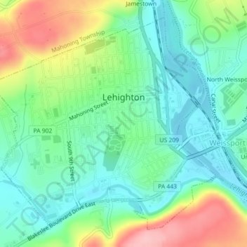
Name: Lehighton topographic map, elevation, terrain.
Location: Lehighton, Carbon County, Pennsylvania, United States (40.81949 -75.73210 40.84271 -75.70007)
Average elevation: 182 m
Minimum elevation: 135 m
Maximum elevation: 277 m
Other topographic maps
Click on a map to view its topography, its elevation and its terrain.
Albrightsville
United States > Pennsylvania > Carbon County > Kidder Township
Average elevation: 498 m
Holiday Poconos
United States > Pennsylvania > Carbon County > Kidder Township
Average elevation: 519 m
Lake Harmony
United States > Pennsylvania > Carbon County > Kidder Township > Lake Harmony
Average elevation: 568 m
Hickory Run State Park
United States > Pennsylvania > Carbon County > Kidder Township
Average elevation: 471 m
Lake Harmony
United States > Pennsylvania > Carbon County > Kidder Township > Lake Harmony
Average elevation: 551 m
Beltzville State Park - Parking Lot B
United States > Pennsylvania > Carbon County > Lehighton
Average elevation: 222 m
Holiday Poconos
United States > Pennsylvania > Carbon County > Kidder Township
Average elevation: 519 m
Albrightsville
United States > Pennsylvania > Carbon County > Kidder Township
Average elevation: 498 m
Holiday Poconos
United States > Pennsylvania > Carbon County > Kidder Township
Average elevation: 519 m
Germans
United States > Pennsylvania > Carbon County > East Penn Township > Germans
Average elevation: 238 m