Geolocate

Columbus topographic map

Click on the map to display elevation.

About this map

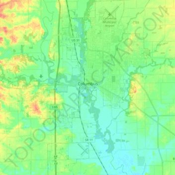
Name: Columbus topographic map, elevation, terrain.

Location: Columbus, Bartholomew County, Indiana, 47203, United States (39.12060 -86.00298 39.27485 -85.85090)

Average elevation: 197 m

Minimum elevation: 181 m

Maximum elevation: 231 m

Other topographic maps

Click on a map to view its topography, its elevation and its terrain.

Gear up for your next adventure:

🥾Men's Waterproof Hiking Boots - Durable footwear with deep lugs for muddy and rocky UK terrains
🧭Professional Hiking Compasses - High-precision liquid-filled compasses for map reading and orientation
🚲Bikepacking Frame Bags - Storage for tools and navigation gear on long off-road rides
🛰️Outdoor GPS Navigation - Navigation devices for remote and off-grid areas
🧼Biodegradable Soap - Leave-no-trace hygiene for multi-day mountain treks

As an Amazon Associate, this site earns from qualifying purchases at no extra cost to you.