
Crows Nest topographic map
Interactive map
Click on the map to display elevation.
About this map
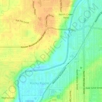
Name: Crows Nest topographic map, elevation, terrain.
Location: Crows Nest, Marion County, Indiana, United States (39.85042 -86.17862 39.86275 -86.16219)
Average elevation: 229 m
Minimum elevation: 213 m
Maximum elevation: 245 m
Other topographic maps
Click on a map to view its topography, its elevation and its terrain.
Drexel Gardens
United States > Indiana > Marion County > Indianapolis
Drexel Gardens, Indianapolis, Marion County, Indiana, 46241, United States
Average elevation: 226 m
Indianapolis
United States > Indiana > Marion County
Indianapolis, Marion County, Indiana, United States
Average elevation: 241 m
Wolfington
United States > Indiana > Marion County > Indianapolis
Wolfington, Indianapolis, Marion County, Indiana, 46228, United States
Average elevation: 230 m
Farleys Addition
United States > Indiana > Marion County > Indianapolis
Farleys Addition, Indianapolis, Marion County, Indiana, 36224, United States
Average elevation: 235 m
Fox Hollow
United States > Indiana > Marion County > Indianapolis > Fox Hollow
Fox Hollow, Indianapolis, Marion County, Indiana, 46239, United States
Average elevation: 252 m