
Thank you for supporting this site ❤️
Make a donation
Make a donation
Gear up for your next adventure:
As an Amazon Associate, this site earns from qualifying purchases at no extra cost to you.
Huberdeau topographic map
Click on the map to display elevation.
Thank you for supporting this site ❤️
Make a donation
Make a donation
Gear up for your next adventure:
As an Amazon Associate, this site earns from qualifying purchases at no extra cost to you.
About this map
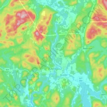
Name: Huberdeau topographic map, elevation, terrain.
Location: Huberdeau, Les Laurentides, Laurentides, Quebec, Canada (45.92914 -74.71039 46.05934 -74.61351)
Average elevation: 266 m
Minimum elevation: 168 m
Maximum elevation: 512 m
Thank you for supporting this site ❤️
Make a donation
Make a donation
Gear up for your next adventure:
As an Amazon Associate, this site earns from qualifying purchases at no extra cost to you.