Geolocate

Bayham topographic map

Click on the map to display elevation.

About this map

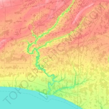
Name: Bayham topographic map, elevation, terrain.

Location: Bayham, Elgin County, Ontario, Canada (42.61385 -80.86021 42.84648 -80.71715)

Average elevation: 217 m

Minimum elevation: 169 m

Maximum elevation: 258 m

Other topographic maps

Click on a map to view its topography, its elevation and its terrain.

Fingal

Canada > Ontario > Elgin County > Southwold

Average elevation: 218 m

Hawk Cliff Woods

Canada > Ontario > Elgin County > Central Elgin

Average elevation: 198 m

Gear up for your next adventure:

🥾Men's Waterproof Hiking Boots - Durable footwear with deep lugs for muddy and rocky UK terrains
🧥Breathable Waterproof Jackets - Essential rain protection for the unpredictable British climate
📱Phone Mounts for Hiking - Secure mounts to carry your phone on trails
🎿Telescopic Trekking Poles - Reduces knee strain on steep topographic descents
🗺️Ordnance Survey Maps - Official UK maps for walking and outdoor activities

As an Amazon Associate, this site earns from qualifying purchases at no extra cost to you.