
Make a donation
Gear up for your next adventure:
As an Amazon Associate, this site earns from qualifying purchases at no extra cost to you.
Barcelona topographic map
Click on the map to display elevation.
Make a donation
Gear up for your next adventure:
As an Amazon Associate, this site earns from qualifying purchases at no extra cost to you.
About this map
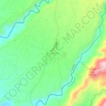
Name: Barcelona topographic map, elevation, terrain.
Average elevation: 1,276 m
Minimum elevation: 1,082 m
Maximum elevation: 1,766 m
Make a donation
Gear up for your next adventure:
As an Amazon Associate, this site earns from qualifying purchases at no extra cost to you.
Other topographic maps
Click on a map to view its topography, its elevation and its terrain.
Salento
The town of Salento itself lies on a plateau above the Quindío river valley. The section of the river valley from Salento to the head of the river is known as the Cocora valley. The town is located at an average altitude of 1895 meters above sea level, with steep drops to the valley floor at its northern and…
Average elevation: 2,335 m
Armenia
Armenia has a territorial area of 29,743 square kilometres (11,484 sq mi). The terrain is mostly mountainous, with fast flowing rivers, and few forests. The land rises to 4,090 metres (13,419 feet) above sea level at Mount Aragats, and no point is below 390 metres (1,280 ft) above sea level. Average elevation…
Average elevation: 1,303 m
Salento
The town of Salento itself lies on a plateau above the Quindío river valley. The section of the river valley from Salento to the head of the river is known as the Cocora valley. The town is located at an average altitude of 1895 meters above sea level, with steep drops to the valley floor at its northern and…
Average elevation: 2,335 m
Make a donation
Gear up for your next adventure:
As an Amazon Associate, this site earns from qualifying purchases at no extra cost to you.
Make a donation
Gear up for your next adventure:
As an Amazon Associate, this site earns from qualifying purchases at no extra cost to you.
Filandia
Filandia is the northernmost town of the Department of Quindío. The town is located on the west slope of the Cordillera Central of the Colombian Andes, on the Alto Cauca basin and the Rio La Vieja sub-basin. The main urban area is located at an altitude of 1923 metres above sea level and the altitude range of…
Average elevation: 1,704 m
Make a donation
Gear up for your next adventure:
As an Amazon Associate, this site earns from qualifying purchases at no extra cost to you.