
Lansing topographic map
Click on the map to display elevation.
Lansing
Lansing elevations range between 890 feet (271 m) above sea level on the far south side of Lansing along Northrup Street near the Cedar Street intersection, to 833 feet (254 m) to 805.5 feet (246 m) above sea level along the Grand River.
About this map
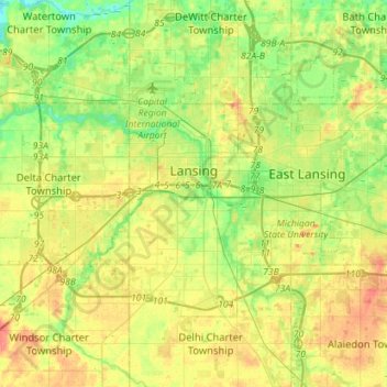
Name: Lansing topographic map, elevation, terrain.
Location: Lansing, Ingham County, Michigan, United States (42.64748 -84.70128 42.79498 -84.41758)
Average elevation: 263 m
Minimum elevation: 239 m
Maximum elevation: 294 m
Other topographic maps
Click on a map to view its topography, its elevation and its terrain.
Burchfield Park
United States > Michigan > Ingham County > Delhi Charter Township
Average elevation: 268 m
Village of Dansville Community Park
United States > Michigan > Ingham County > Dansville
Average elevation: 289 m