
Nallamala Hills topographic map
Interactive map
Click on the map to display elevation.
Nallamala Hills
The Nallamalas (also called the Nallamalla Range) are a section of the Eastern Ghats which forms the eastern boundary of Rayalaseema region of the state of Andhra Pradesh and Mahabubnagar, Nalgonda districts of the state of Telangana, in India. They run in a nearly north-south alignment, parallel to the Coromandel Coast for close to 430 km between the rivers, Krishna and Pennar. Its northern boundaries are marked by the flat Palnadu basin while in the south it merges with the Tirupati hills. An extremely old system, the hills have extensively weathered and eroded over the years. The average elevation today is about 520 m which reaches 1100 m at Bhairani Konda and 1048 m at Gundla Brahmeswara. Both of these peaks are in a north westerly direction from the town of Cumbum. There are also many other peaks above 800m.
About this map
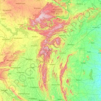
Name: Nallamala Hills topographic map, elevation, terrain.
Location: Nallamala Hills, Telangana, India (14.70815 78.30085 16.54640 79.55086)
Average elevation: 278 m
Minimum elevation: 22 m
Maximum elevation: 961 m
Other topographic maps
Click on a map to view its topography, its elevation and its terrain.
Bhadrachalam
Bhadrachalam is located at 17°40′N 80°53′E / 17.67°N 80.88°E / 17.67; 80.88. It has an average elevation of 50 metres (164 feet). The zero feet gauge level of Godavari River at Bhadracham is equal to +32.6 m msl.
Average elevation: 52 m
Kalkoda
India > Telangana > Marpalle mandal
Kalkoda is located at 17°28′31″N 77°43′34″E / 17.475388°N 77.726030°E / 17.475388; 77.726030. It has an average elevation of 617 metres (2027 ft).
Average elevation: 590 m
Adilabad
India > Telangana > Adilabad Urban Mandal
Adilabad has an average elevation of 264 metres. The district shares its boundaries with Nirmal districts of Telangana to the south, Komaram Bheem district on the east, with Nanded on the west and Yavatmal and Chandrapur districts of Maharashtra to the north.
Average elevation: 310 m
Sitha Vanigudem
India > Telangana > B. Pochampally mandal > Bhoodan Pochampally
Average elevation: 391 m
Aleru
India > Telangana > Alair mandal
Aler is located at 17°39′00″N 79°03′00″E / 17.6500°N 79.0500°E / 17.6500; 79.0500. It has an average elevation of 361 meters (1187 ft).
Average elevation: 370 m
Chandur
India > Telangana > Chandur mandal
Chandur is located at 16°59′N 79°04′E / 16.98°N 79.06°E / 16.98; 79.06. It has an average elevation of 484 metres (1587 feet).
Average elevation: 256 m
Warangal
India > Telangana > Warangal mandal
Warangal is located at 18°00′N 79°35′E / 18.0°N 79.58°E / 18.0; 79.58. It has an average elevation of 302 metres (990 feet). It is settled in the eastern part of Deccan Plateau made up of granite rocks and hill formations which left the region barren making the cultivation dependent on…
Average elevation: 268 m