
Vodná nádrž Veľká Domaša topographic map
Interactive map
Click on the map to display elevation.
Vodná nádrž Veľká Domaša
Domaša is spread over the area of the districts of Vranov nad Topľou and Stropkov at the average altitude of 156 m (512 ft). With an agreeable climate and an average temperature of 23 °C (73 °F) it guarantees pleasant swimming in clean water from June to mid-September.
About this map
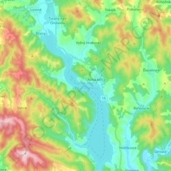
Name: Vodná nádrž Veľká Domaša topographic map, elevation, terrain.
Average elevation: 268 m
Minimum elevation: 146 m
Maximum elevation: 526 m
Other topographic maps
Click on a map to view its topography, its elevation and its terrain.
Nová Kelča
Slovakia > Region of Prešov > District of Vranov nad Topľou > Nová Kelča
Average elevation: 231 m