
Make a donation
Gear up for your next adventure:
As an Amazon Associate, this site earns from qualifying purchases at no extra cost to you.
Tofino topographic map
Click on the map to display elevation.
Make a donation
Gear up for your next adventure:
As an Amazon Associate, this site earns from qualifying purchases at no extra cost to you.
About this map
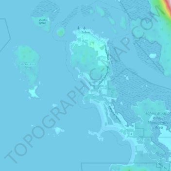
Name: Tofino topographic map, elevation, terrain.
Average elevation: 8 m
Minimum elevation: -1 m
Maximum elevation: 578 m
Make a donation
Gear up for your next adventure:
As an Amazon Associate, this site earns from qualifying purchases at no extra cost to you.
Other topographic maps
Click on a map to view its topography, its elevation and its terrain.
Bamfield
Canada > British Columbia > Alberni-Clayoquot Regional District > Area A (Bamfield)
Average elevation: 16 m
Klitsa Mountain
Canada > British Columbia > Alberni-Clayoquot Regional District > Area D (Sproat Lake)
Average elevation: 1,108 m
Triple Peak
Canada > British Columbia > Alberni-Clayoquot Regional District > Area C (Long Beach)
Average elevation: 938 m
Seabird Rocks
Canada > British Columbia > Alberni-Clayoquot Regional District > Area A (Bamfield)
Average elevation: 0 m
Make a donation
Gear up for your next adventure:
As an Amazon Associate, this site earns from qualifying purchases at no extra cost to you.
Lyall Point
Canada > British Columbia > Alberni-Clayoquot Regional District > Area C (Long Beach)
Average elevation: 1 m
Ahousaht
Canada > British Columbia > Alberni-Clayoquot Regional District > Area C (Long Beach)
Average elevation: 14 m
Pogo Mountain
Canada > British Columbia > Alberni-Clayoquot Regional District > Area C (Long Beach)
Average elevation: 818 m
View Lake
Canada > British Columbia > Alberni-Clayoquot Regional District > Area D (Sproat Lake)
Average elevation: 393 m
Make a donation
Gear up for your next adventure:
As an Amazon Associate, this site earns from qualifying purchases at no extra cost to you.
Ahousaht
Canada > British Columbia > Alberni-Clayoquot Regional District > Area C (Long Beach)
Average elevation: 20 m
5040 Peak
Canada > British Columbia > Alberni-Clayoquot Regional District > Area D (Sproat Lake)
Average elevation: 1,092 m
Escalante River
Canada > British Columbia > Alberni-Clayoquot Regional District > Area C (Long Beach)
Average elevation: 419 m
Long Beach
Canada > British Columbia > Alberni-Clayoquot Regional District > Area C (Long Beach)
Average elevation: 21 m
Make a donation
Gear up for your next adventure:
As an Amazon Associate, this site earns from qualifying purchases at no extra cost to you.
Love Lake
Canada > British Columbia > Alberni-Clayoquot Regional District > Area D (Sproat Lake)
Average elevation: 1,338 m
Lone Cone
Canada > British Columbia > Alberni-Clayoquot Regional District > Area C (Long Beach)
Average elevation: 210 m
Kakawis
Canada > British Columbia > Alberni-Clayoquot Regional District > Area C (Long Beach)
Average elevation: 50 m
Comox Glacier
Canada > British Columbia > Alberni-Clayoquot Regional District > Area D (Sproat Lake)
Average elevation: 1,584 m
Make a donation
Gear up for your next adventure:
As an Amazon Associate, this site earns from qualifying purchases at no extra cost to you.
Great Central
Canada > British Columbia > Alberni-Clayoquot Regional District > Area D (Sproat Lake)
Average elevation: 158 m
China Creek
Canada > British Columbia > Alberni-Clayoquot Regional District > Area F (Cherry Creek)
Average elevation: 664 m
Dry Creek Valley
Canada > British Columbia > Alberni-Clayoquot Regional District > Area F (Cherry Creek)
Average elevation: 175 m
Comox Glacier
Canada > British Columbia > Alberni-Clayoquot Regional District > Area D (Sproat Lake)
Average elevation: 1,584 m
Make a donation
Gear up for your next adventure:
As an Amazon Associate, this site earns from qualifying purchases at no extra cost to you.