
Thank you for supporting this site ❤️
Make a donation
Make a donation
Gear up for your next adventure:
As an Amazon Associate, this site earns from qualifying purchases at no extra cost to you.
Iten topographic map
Click on the map to display elevation.
Thank you for supporting this site ❤️
Make a donation
Make a donation
Gear up for your next adventure:
As an Amazon Associate, this site earns from qualifying purchases at no extra cost to you.
About this map
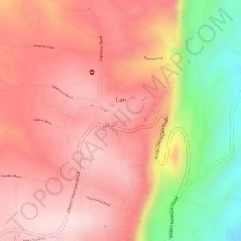
Name: Iten topographic map, elevation, terrain.
Location: Iten, Keiyo North, Elgeyo-Marakwet County, Kenya (0.65379 35.49494 0.68086 35.51646)
Average elevation: 2,281 m
Minimum elevation: 2,055 m
Maximum elevation: 2,391 m
Thank you for supporting this site ❤️
Make a donation
Make a donation
Gear up for your next adventure:
As an Amazon Associate, this site earns from qualifying purchases at no extra cost to you.