Geolocate

Vergato topographic map

Click on the map to display elevation.

About this map

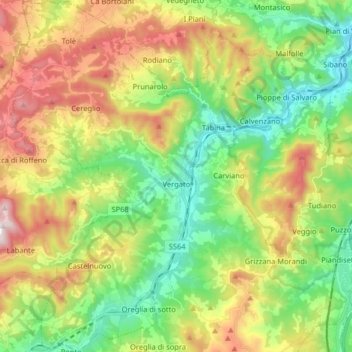
Name: Vergato topographic map, elevation, terrain.

Location: Vergato, Unione dell'Appennino Bolognese, Bologna, Emilia-Romagna, 40038, Italy (44.22750 11.03113 44.34284 11.16117)

Average elevation: 467 m

Minimum elevation: 140 m

Maximum elevation: 995 m

Other topographic maps

Click on a map to view its topography, its elevation and its terrain.

Lucchio

Italy > Emilia-Romagna > Bologna > Montefredente

Average elevation: 716 m

Riccardina

Italy > Emilia-Romagna > Bologna > Budrio

Average elevation: 20 m

Tabina

Italy > Emilia-Romagna > Bologna

Average elevation: 366 m

Gear up for your next adventure:

🔦Outdoor Torches - Reliable torches for night navigation
🎒Multi-day Trekking Packs - Large capacity backpacks for wild camping and long-distance trails
🥾Walking Shoes - Lightweight walking shoes for countryside and coastal paths
🛰️Satellite Messengers - Emergency communication devices for areas without mobile signal
🧭GPS Trackers - Tracking devices for safety and navigation

As an Amazon Associate, this site earns from qualifying purchases at no extra cost to you.