
Thank you for supporting this site ❤️
Make a donation
Make a donation
Gear up for your next adventure:
As an Amazon Associate, this site earns from qualifying purchases at no extra cost to you.
Ananea topographic map
Click on the map to display elevation.
Thank you for supporting this site ❤️
Make a donation
Make a donation
Gear up for your next adventure:
As an Amazon Associate, this site earns from qualifying purchases at no extra cost to you.
About this map
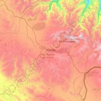
Name: Ananea topographic map, elevation, terrain.
Location: Ananea, Province of San Antonio de Putina, Puno, Peru (-14.85504 -69.75803 -14.50809 -69.22487)
Average elevation: 4,515 m
Minimum elevation: 2,865 m
Maximum elevation: 5,793 m
Thank you for supporting this site ❤️
Make a donation
Make a donation
Gear up for your next adventure:
As an Amazon Associate, this site earns from qualifying purchases at no extra cost to you.