
Grafton topographic map
Interactive map
Click on the map to display elevation.
About this map
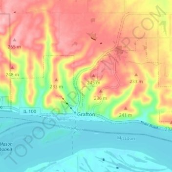
Name: Grafton topographic map, elevation, terrain.
Location: Grafton, Jersey County, Illinois, United States (38.96384 -90.45988 38.99228 -90.39490)
Average elevation: 186 m
Minimum elevation: 126 m
Maximum elevation: 260 m
Other topographic maps
Click on a map to view its topography, its elevation and its terrain.
Dow
United States > Illinois > Jersey County
Dow, Jersey County, Illinois, 62022, United States
Average elevation: 197 m
Jerseyville
United States > Illinois > Jersey County
Jerseyville, Jersey County, Illinois, 62052, United States
Average elevation: 188 m