Geolocate

Lessines topographic map

Click on the map to display elevation.

About this map
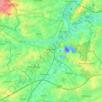
Name: Lessines topographic map, elevation, terrain.

Location: Lessines, Ath, Hainaut, Wallonia, Belgium (50.66940 3.74512 50.75161 3.91346)

Average elevation: 39 m

Minimum elevation: -103 m

Maximum elevation: 134 m

Other topographic maps

Click on a map to view its topography, its elevation and its terrain.

Vaudignies

Belgium > Hainaut > Ath

Average elevation: 64 m

Bois - Ten Bosse

Belgium > Hainaut > Ath

Average elevation: 88 m

La Houppe - Hoppeberg

Belgium > Hainaut > Ath

Average elevation: 105 m

Southern Cape

Belgium > Hainaut > Ath > Cambron-Casteau

Average elevation: 62 m

Pottelberg

Belgium > Hainaut > Ath

Average elevation: 106 m

Cambron-Casteau

Belgium > Hainaut > Ath > Brugelette (section)

Average elevation: 59 m

Gear up for your next adventure:

⛺Camping Shelters - Emergency and lightweight shelters for outdoor use
🧣Fleece Neck Warmers - Extra insulation for winter topographic surveys
🧥Softshell Jackets - Breathable jackets for active outdoor use
🧤Thermal Touchscreen Gloves - Stay warm while operating your GPS or smartphone camera
🔥Emergency Fire Starters - Reliable ignition tools for survival situations in damp conditions

As an Amazon Associate, this site earns from qualifying purchases at no extra cost to you.