Geolocate

Tralee topographic map

Click on the map to display elevation.

About this map

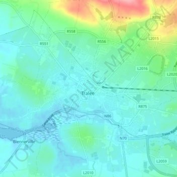
Name: Tralee topographic map, elevation, terrain.

Location: Tralee, County Kerry, Munster, Ireland (52.24845 -9.74042 52.29270 -9.65746)

Average elevation: 20 m

Minimum elevation: -2 m

Maximum elevation: 106 m

Other topographic maps

Click on a map to view its topography, its elevation and its terrain.

Knocknagashel

Ireland > County Kerry

Average elevation: 154 m

Stradbally Mountain

Ireland > County Kerry

Average elevation: 487 m

Glencar

Ireland > County Kerry

Average elevation: 114 m

Beaufort

Ireland > County Kerry

Average elevation: 41 m

Glencloosagh Bay

Ireland > County Kerry

Average elevation: 12 m

Castlegregory

Ireland > County Kerry

Average elevation: 17 m

Murreagh

Ireland > County Kerry

Average elevation: 37 m

Brandon Mountain

Ireland > County Kerry

Average elevation: 572 m

Kenmare

Ireland > County Kerry > Kenmare

Average elevation: 87 m

Scartaglin

Ireland > County Kerry > Scartaglin

Average elevation: 135 m

Ballyduff

Ireland > County Kerry > Ballyduff

Average elevation: 29 m

Rathmore

Ireland > County Kerry > Rathmore

Average elevation: 154 m

Brick

Ireland > County Kerry

Average elevation: 4 m

Killorglin

Ireland > County Kerry > Killorglin

Average elevation: 24 m

Kilmorna

Ireland > County Kerry

Average elevation: 65 m

Gear up for your next adventure:

📍Handheld GPS Navigators - Reliable satellite navigation for hiking and off-road exploration
🖼️Topographic Map Art - Decorative 3D-effect posters of famous UK peaks and regions
🚲Bikepacking Frame Bags - Storage for tools and navigation gear on long off-road rides
🛰️Handheld GPS Devices - Reliable GPS units for hiking and outdoor navigation
🦯Walking Poles - Supportive poles for long-distance walking

As an Amazon Associate, this site earns from qualifying purchases at no extra cost to you.