
Make a donation
Gear up for your next adventure:
As an Amazon Associate, this site earns from qualifying purchases at no extra cost to you.
Puyo topographic map
Click on the map to display elevation.
Make a donation
Gear up for your next adventure:
As an Amazon Associate, this site earns from qualifying purchases at no extra cost to you.
Puyo
Puyo (Spanish pronunciation: [ˈpuʝo]), also known as El Puyo, is the capital of Pastaza, a province in Ecuador. Puyo is located at an altitude of approximately 950 metres above sea level by the Puyo River, a tributary of the Pastaza River, which eventually leads into the Amazon River. True to its name, derived from the Kichwa word for "cloudy", the local climate is a wet one and the weather is often overcast.
Make a donation
Gear up for your next adventure:
As an Amazon Associate, this site earns from qualifying purchases at no extra cost to you.
About this map
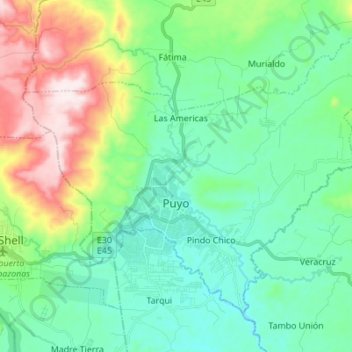
Name: Puyo topographic map, elevation, terrain.
Location: Puyo, Pastaza, Ecuador (-1.52890 -78.05687 -1.42083 -77.91932)
Average elevation: 1,022 m
Minimum elevation: 880 m
Maximum elevation: 1,408 m
Make a donation
Gear up for your next adventure:
As an Amazon Associate, this site earns from qualifying purchases at no extra cost to you.
Other topographic maps
Click on a map to view its topography, its elevation and its terrain.