
Mühlhausen topographic map
Interactive map
Click on the map to display elevation.
About this map
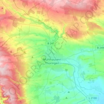
Name: Mühlhausen topographic map, elevation, terrain.
Location: Mühlhausen, Unstrut-Hainich-Kreis, Thuringia, Germany (51.14553 10.36172 51.30347 10.57395)
Average elevation: 288 m
Minimum elevation: 175 m
Maximum elevation: 486 m
Mühlhausen is situated in the flat landscape of the Thuringian Basin, a very fertile area covering the northern centre of Thuringia at an elevation of approximately 215 metres above sea level. To the north and west, the terrain gets hilly, whereas to the south and east lie wide agricultural areas, much like most of the municipal territory itself. Furthermore, there are two forests within the territory: the Stadtwald (as part of the Hainich) in the west and the Mühlhäuser Hardt between the Windeberg district and Menteroda. Both are broadleaf forests with beeches prevalent. The Hainich hills south-west of Mühlhausen became Thuringia's only National Park in 1997 because of their old near-natural beech forests. The highest hills within the Mühlhausen terrain reach approximately 400 metres of elevation. The main river crossing the city in northwest–southeast direction is the Unstrut. Furthermore, there are many small tributaries running from the western hills through Mühlhausen to the Unstrut like the Schwemmnotte, which is dividing the inner city.
Other topographic maps
Click on a map to view its topography, its elevation and its terrain.
Höngeda
Germany > Thuringia > Unstrut-Hainich-Kreis > Mühlhausen
Höngeda, Mühlhausen, Unstrut-Hainich-Kreis, Thuringia, 99998, Germany
Average elevation: 202 m
Unstrut-Hainich
Germany > Thuringia > Unstrut-Hainich-Kreis > Unstrut-Hainich
Unstrut-Hainich, Unstrut-Hainich-Kreis, Thuringia, 99991, Germany
Average elevation: 279 m
Rodeberg
Germany > Thuringia > Unstrut-Hainich-Kreis > Rodeberg
Rodeberg, Südeichsfeld, Unstrut-Hainich-Kreis, Thuringia, Germany
Average elevation: 422 m
Thamsbrück
Germany > Thuringia > Unstrut-Hainich-Kreis > Bad Langensalza > Thamsbrück
Thamsbrück, Bad Langensalza, Unstrut-Hainich-Kreis, Thuringia, 99947, Germany
Average elevation: 189 m