Prévonloup topographic map
Interactive map
Click on the map to display elevation.
About this map
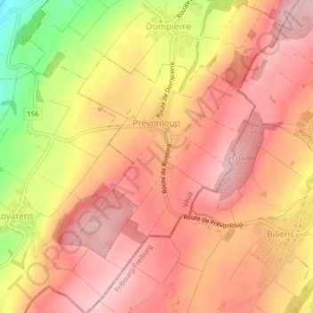
Name: Prévonloup topographic map, elevation, terrain.
Location: Prévonloup, District de la Broye-Vully, Vaud, Switzerland (46.68818 6.87115 46.70561 6.89446)
Average elevation: 744 m
Minimum elevation: 606 m
Maximum elevation: 809 m
Other topographic maps
Click on a map to view its topography, its elevation and its terrain.
Forel-sur-Lucens
Switzerland > Vaud > District de la Broye-Vully
Forel-sur-Lucens, Lucens, District de la Broye-Vully, Vaud, 1526, Switzerland
Average elevation: 672 m
La Broye
Switzerland > Vaud > District de la Broye-Vully
La Broye, District de la Broye-Vully, Vaud, 1530, Switzerland
Average elevation: 735 m
Payerne
Switzerland > Vaud > District de la Broye-Vully > Payerne
Payerne, District de la Broye-Vully, Vaud, Switzerland
Average elevation: 495 m