
Terni topographic map
Interactive map
Click on the map to display elevation.
About this map
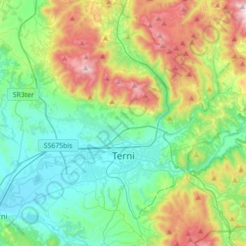
Name: Terni topographic map, elevation, terrain.
Location: Terni, Umbria, 05100, Italy (42.50033 12.54215 42.67578 12.78719)
Average elevation: 411 m
Minimum elevation: 91 m
Maximum elevation: 1,181 m
Other topographic maps
Click on a map to view its topography, its elevation and its terrain.
Calvi dell'Umbria
Calvi dell'Umbria, Terni, Umbria, 05032, Italy
Average elevation: 355 m
Monte Torre Maggiore
Italy > Umbria > Terni > Terni
Monte Torre Maggiore, Terni, Umbria, 05100, Italy
Average elevation: 867 m