
Bardstown topographic map
Interactive map
Click on the map to display elevation.
About this map
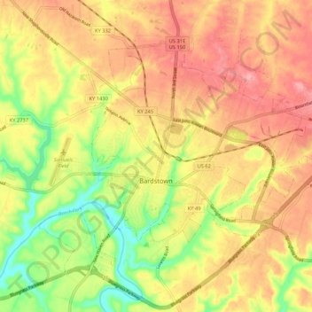
Name: Bardstown topographic map, elevation, terrain.
Location: Bardstown, Nelson County, Kentucky, 40004, United States (37.78499 -85.50648 37.84646 -85.40101)
Average elevation: 199 m
Minimum elevation: 136 m
Maximum elevation: 247 m
Other topographic maps
Click on a map to view its topography, its elevation and its terrain.
Boston
United States > Kentucky > Nelson County
Boston, Nelson County, Kentucky, United States
Average elevation: 145 m
Bardstown
United States > Kentucky > Nelson County > Bardstown > Bardstown
Bardstown, Nelson County, Kentucky, 40004, United States
Average elevation: 197 m