
Marathon topographic map
Interactive map
Click on the map to display elevation.
About this map
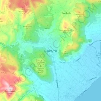
Name: Marathon topographic map, elevation, terrain.
Average elevation: 146 m
Minimum elevation: -1 m
Maximum elevation: 564 m
World records were not officially recognized by the IAAF until 1 January 2004; previously, the best times for the marathon were referred to as the 'world best'. Courses must conform to IAAF standards for a record to be recognized. However, marathon routes still vary greatly in elevation, course, and surface, making exact comparisons impossible. Typically, the fastest times are set over relatively flat courses near sea level, during good weather conditions and with the assistance of pacesetters.
Other topographic maps
Click on a map to view its topography, its elevation and its terrain.
Rafina
Greece > Attica > Regional Unit of East Attica > Rafina Municipal Unit
Rafina, Rafina Municipal Unit, Municipality of Rafina - Pikermi, Regional Unit of East Attica, Attica, 190 09, Greece
Average elevation: 44 m
Astypalaia
Greece > Attica > Regional Unit of East Attica > Anavissos Municipal Unit
Astypalaia, Anavissos Municipal Unit, Municipality of Saronikos, Regional Unit of East Attica, Attica, 190 13, Greece
Average elevation: 10 m
Ανάβυσσος
Greece > Attica > Regional Unit of East Attica > Anavissos Municipal Unit
Ανάβυσσος, Anavissos Municipal Unit, Municipality of Saronikos, Regional Unit of East Attica, Attica, 190 13, Greece
Average elevation: 91 m
Koropi
Greece > Attica > Regional Unit of East Attica
Koropi, Municipality of Kropia, Regional Unit of East Attica, Attica, 194 00, Greece
Average elevation: 148 m
Nea Makri Municipal Unit
Greece > Attica > Regional Unit of East Attica
Nea Makri Municipal Unit, Municipality of Marathonas, Regional Unit of East Attica, Attica, 190 05, Greece
Average elevation: 217 m
Christoupoli
Greece > Attica > Regional Unit of East Attica > Spata-Loutsa Municipal Unit
Christoupoli, Spata-Loutsa Community, Spata-Loutsa Municipal Unit, Municipality of Spata - Artemida, Regional Unit of East Attica, Attica, 190 04, Greece
Average elevation: 122 m
Limenas Markopoulou
Greece > Attica > Regional Unit of East Attica
Limenas Markopoulou, Municipality of Markopoulo Mesogaias, Regional Unit of East Attica, Attica, 190 23, Greece
Average elevation: 93 m
Municipal Unit of Voula
Greece > Attica > Regional Unit of East Attica
Municipal Unit of Voula, Municipality of Vari - Voula - Vouliagmeni, Regional Unit of East Attica, Attica, 166 73, Greece
Average elevation: 57 m
Glyka Nera Municipal Unit
Greece > Attica > Regional Unit of East Attica
Glyka Nera Municipal Unit, Municipality of Paiania, Regional Unit of East Attica, Attica, 153 54, Greece
Average elevation: 309 m
Artemida
Greece > Attica > Regional Unit of East Attica > Artemida Municipal Unit
Artemida, Artemida Municipal Unit, Municipality of Spata - Artemida, Regional Unit of East Attica, Attica, 190 16, Greece
Average elevation: 38 m
Municipality of Lavreotiki
Greece > Attica > Regional Unit of East Attica
Municipality of Lavreotiki, Regional Unit of East Attica, Attica, Greece
Average elevation: 80 m
Gerakas Municipal Unit
Greece > Attica > Regional Unit of East Attica
Gerakas Municipal Unit, Municipality of Pallini, Regional Unit of East Attica, Attica, 153 44, Greece
Average elevation: 259 m
Vouliagmeni Municipal Unit
Greece > Attica > Regional Unit of East Attica
Vouliagmeni Municipal Unit, Municipality of Vari - Voula - Vouliagmeni, Regional Unit of East Attica, Attica, 166 71, Greece
Average elevation: 20 m
Pikermi Municipal Unit
Greece > Attica > Regional Unit of East Attica > Pikermi Municipal Unit
Pikermi Municipal Unit, Municipality of Rafina - Pikermi, Regional Unit of East Attica, Attica, Greece
Average elevation: 227 m
Anavissos Municipal Unit
Greece > Attica > Regional Unit of East Attica
Anavissos Municipal Unit, Municipality of Saronikos, Regional Unit of East Attica, Attica, Greece
Average elevation: 60 m
Mount Parnitha National Park
Greece > Attica > Regional Unit of East Attica
Mount Parnitha National Park, Regional Unit of East Attica, Attica, Greece
Average elevation: 543 m