
Bhojpur topographic map
Interactive map
Click on the map to display elevation.
About this map
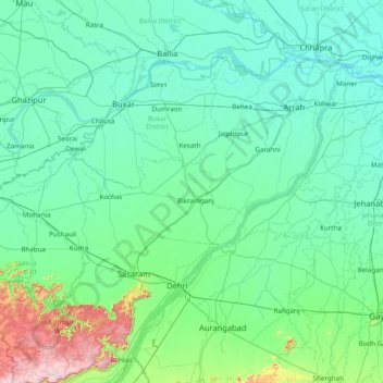
Name: Bhojpur topographic map, elevation, terrain.
Location: Bhojpur, Rohtas District, Bihar, India (24.55000 83.55000 25.95000 84.95000)
Average elevation: 104 m
Minimum elevation: 44 m
Maximum elevation: 635 m
Other topographic maps
Click on a map to view its topography, its elevation and its terrain.
Koshi River
The Kosi River catchment covers six geological and climatic belts varying in altitude from above 8,000 m (26,000 ft) to 95 m (312 ft) comprising the Tibetan plateau, the Himalayas, the Himalayan mid-hill belt, the Mahabharat Range, the Siwalik Hills and the Terai. The Dudh-Koshi sub-basin alone consists of 36…
Average elevation: 82 m