
Loa topographic map
Interactive map
Click on the map to display elevation.
About this map
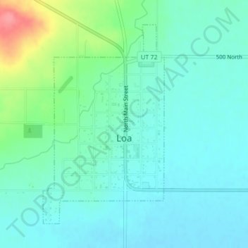
Name: Loa topographic map, elevation, terrain.
Location: Loa, Wayne County, Utah, 84747, United States (38.39343 -111.65426 38.41513 -111.63738)
Average elevation: 2,158 m
Minimum elevation: 2,140 m
Maximum elevation: 2,220 m
Other topographic maps
Click on a map to view its topography, its elevation and its terrain.
Bullard Spring
United States > Utah > Wayne County
Bullard Spring, South 200W, Wayne County, Utah, 84715, United States
Average elevation: 2,156 m
Caineville
United States > Utah > Wayne County
Caineville, Wayne County, Utah, United States
Average elevation: 1,465 m
Fruita
United States > Utah > Wayne County > Fruita
Fruita, Wayne County, Utah, United States
Average elevation: 1,803 m
Hanksville
United States > Utah > Wayne County
Hanksville, Wayne County, Utah, 84734, United States
Average elevation: 1,330 m
Torrey
United States > Utah > Wayne County > Torrey > Torrey
Torrey, Wayne County, Utah, 84773, United States
Average elevation: 2,089 m
Canyonlands National Park
United States > Utah > Wayne County
Canyonlands National Park, Wayne County, Utah, United States
Average elevation: 1,640 m
Torrey
United States > Utah > Wayne County
Torrey, Wayne County, Utah, United States
Average elevation: 2,090 m