
St. Croix topographic map
Interactive map
Click on the map to display elevation.
About this map
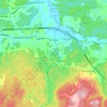
Name: St. Croix topographic map, elevation, terrain.
Average elevation: 67 m
Minimum elevation: 3 m
Maximum elevation: 183 m
Other topographic maps
Click on a map to view its topography, its elevation and its terrain.
Windsor
Canada > Nova Scotia > Hants County
Windsor, Region of Windsor and West Hants Municipality, Hants County, Nova Scotia, B0N 2T0, Canada
Average elevation: 13 m
East Walton
Canada > Nova Scotia > Hants County > East Walton
East Walton, East Hants District Municipality, Hants County, Nova Scotia, B0N 2R0, Canada
Average elevation: 34 m
Scotch Village
Canada > Nova Scotia > Hants County > Scotch Village
Scotch Village, Region of Windsor and West Hants Municipality, Hants County, Nova Scotia, B0N 2G0, Canada
Average elevation: 31 m
Martock
Canada > Nova Scotia > Hants County
Martock, Region of Windsor and West Hants Municipality, Hants County, Nova Scotia, B0N 2T0, Canada
Average elevation: 65 m