
Make a donation
Gear up for your next adventure:
As an Amazon Associate, this site earns from qualifying purchases at no extra cost to you.
Breckenridge topographic map
Click on the map to display elevation.
Make a donation
Gear up for your next adventure:
As an Amazon Associate, this site earns from qualifying purchases at no extra cost to you.
Breckenridge
At the 2020 United States Census, the town had a total area of 6.047 square miles (15.661 km2), all of it land. The ski area has a total area of 2,880 acres (11.7 km2) of land. The elevation of Breckenridge is 9,600 feet (2,900 m) above sea level.
Make a donation
Gear up for your next adventure:
As an Amazon Associate, this site earns from qualifying purchases at no extra cost to you.
About this map
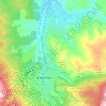
Name: Breckenridge topographic map, elevation, terrain.
Location: Breckenridge, Summit County, Colorado, United States (39.46183 -106.07203 39.54046 -106.01439)
Average elevation: 3,072 m
Minimum elevation: 2,802 m
Maximum elevation: 3,809 m
Make a donation
Gear up for your next adventure:
As an Amazon Associate, this site earns from qualifying purchases at no extra cost to you.
Other topographic maps
Click on a map to view its topography, its elevation and its terrain.
Argentine Pass
United States > Colorado > Summit County
Argentine Pass, elevation 13,207 ft (4,025 m), is a high mountain pass that crosses the Continental Divide in the Front Range of the Rocky Mountains of central Colorado in the United States. Argentine Pass is located on the crest of the Front Range along the boundary southwest of Georgetown and is the highest…
Average elevation: 3,797 m
Make a donation
Gear up for your next adventure:
As an Amazon Associate, this site earns from qualifying purchases at no extra cost to you.