
Dellys topographic map
Interactive map
Click on the map to display elevation.
About this map
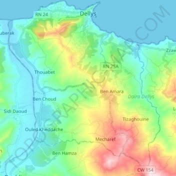
Name: Dellys topographic map, elevation, terrain.
Location: Dellys, Dellys District, Boumerdes, Algeria (36.81750 3.85260 36.92359 3.96751)
Average elevation: 143 m
Minimum elevation: -3 m
Maximum elevation: 571 m
Other topographic maps
Click on a map to view its topography, its elevation and its terrain.
Tagdemt
Algeria > Boumerdès > Dellys District > Dellys
Tagdemt, Dellys, Dellys District, Boumerdes, 35100, Algeria
Average elevation: 64 m