
Noërs topographic map
Interactive map
Click on the map to display elevation.
About this map
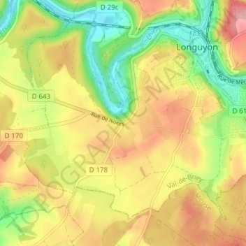
Name: Noërs topographic map, elevation, terrain.
Average elevation: 266 m
Minimum elevation: 203 m
Maximum elevation: 326 m
Other topographic maps
Click on a map to view its topography, its elevation and its terrain.
Machelle
France > Grand Est > Meurthe-et-Moselle > Longuyon
Machelle, Longuyon, Briey, Meurthe-et-Moselle, Grand Est, France métropolitaine, 54260, France
Average elevation: 318 m
Villancy
France > Grand Est > Meurthe-et-Moselle > Longuyon
Villancy, Longuyon, Val-de-Briey, Meurthe-et-Moselle, Grand Est, France métropolitaine, 54260, France
Average elevation: 347 m