
Pass Lake topographic map
Interactive map
Click on the map to display elevation.
About this map
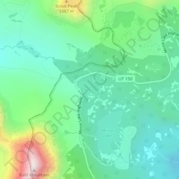
Name: Pass Lake topographic map, elevation, terrain.
Average elevation: 3,144 m
Minimum elevation: 2,966 m
Maximum elevation: 3,638 m
Other topographic maps
Click on a map to view its topography, its elevation and its terrain.
Vernal
United States of America > Utah > Vernal
Vernal, Uintah County, Utah, 84078, United States of America
Average elevation: 1,633 m
Milford
United States of America > Utah > Milford
Milford, Beaver County, Utah, 84751, United States of America
Average elevation: 1,523 m
Duck Creek Village
United States of America > Utah > Duck Creek Village
Duck Creek Village, Kane County, Utah, 85476, United States of America
Average elevation: 2,608 m
Frisco Peak
United States of America > Utah
Frisco Peak, Beaver County, Utah, United States of America
Average elevation: 2,492 m
Aspen Grove
United States of America > Utah > Aspen Grove
Aspen Grove, Utah, United States of America
Average elevation: 2,358 m
Millcreek Park
United States of America > Utah > St. George
Millcreek Park, Middleton, St. George, Washington County, Utah, United States of America
Average elevation: 814 m