
Aranc topographic map
Interactive map
Click on the map to display elevation.
Aranc
The commune lies in the Aranc Valley 10 km north-east of Amberieu-en-Bugey and 25 km south-east of Bourg-en-Bresse. It is bordered to the east by the mountains of Ain and Tré Pellay (1016 metres), in the north by the Avocat mountain chain, and in the west by the valley of the Mandorne. The Aranc Valley has an average altitude of 780 metres. A marsh borders the village to the north. The Borrey river has its source in the marsh. The mountains of Aranc (924 metres) creates a natural border to the east. The lowest point of the commune is the hamlet of Moment at 406 metres.
About this map
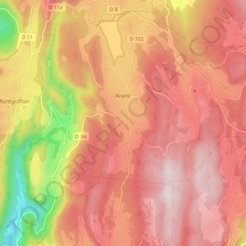
Name: Aranc topographic map, elevation, terrain.
Average elevation: 797 m
Minimum elevation: 398 m
Maximum elevation: 1,013 m
Other topographic maps
Click on a map to view its topography, its elevation and its terrain.
Mas Finet
France > Auvergne-Rhône-Alpes > Ain > Villieu-Loyes-Mollon > Mollon
Average elevation: 256 m
Étang du Chêne
France > Auvergne-Rhône-Alpes > Ain > Saint-André-sur-Vieux-Jonc > Domaine du Suc
Average elevation: 259 m