Geolocate

La Broye topographic map

Interactive map

Click on the map to display elevation.

About this map

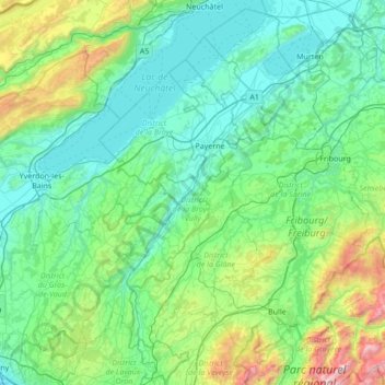
Name: La Broye topographic map, elevation, terrain.

Location: La Broye, District de la Broye-Vully, Vaud, 1530, Switzerland (46.52980 6.78783 46.99698 7.11884)

Average elevation: 735 m

Minimum elevation: 402 m

Maximum elevation: 2,323 m

Other topographic maps

Click on a map to view its topography, its elevation and its terrain.

Forel-sur-Lucens

Switzerland > Vaud > District de la Broye-Vully

Forel-sur-Lucens, Lucens, District de la Broye-Vully, Vaud, 1526, Switzerland

Average elevation: 672 m

Payerne

Switzerland > Vaud > District de la Broye-Vully > Payerne

Payerne, District de la Broye-Vully, Vaud, Switzerland

Average elevation: 495 m