
Ptolemaida topographic map
Interactive map
Click on the map to display elevation.
About this map
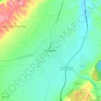
Name: Ptolemaida topographic map, elevation, terrain.
Average elevation: 621 m
Minimum elevation: 577 m
Maximum elevation: 745 m
Other topographic maps
Click on a map to view its topography, its elevation and its terrain.
Κοιλάδα
Greece > Epirus and Western Macedonia > Kozani Regional Unit
Κοιλάδα, Municipality of Kozani, Kozani Regional Unit, Western Macedonia, Epirus and Western Macedonia, 501 00, Greece
Average elevation: 779 m
Ζαπάτιστα
Greece > Epirus and Western Macedonia > Kozani Regional Unit > Πεντάλοφος
Ζαπάτιστα, Πεντάλοφος, Voio Municipality, Kozani Regional Unit, Western Macedonia, Epirus and Western Macedonia, 500 07, Greece
Average elevation: 1,085 m
Κοζάνη
Greece > Epirus and Western Macedonia > Kozani Regional Unit
Κοζάνη, Municipality of Kozani, Kozani Regional Unit, Western Macedonia, Epirus and Western Macedonia, 501 00, Greece
Average elevation: 766 m