
Walcheren topographic map
Interactive map
Click on the map to display elevation.
About this map
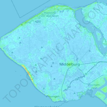
Name: Walcheren topographic map, elevation, terrain.
Location: Walcheren, Zeeland, Netherlands (51.43817 3.43203 51.59506 3.70681)
Average elevation: 0 m
Minimum elevation: -4 m
Maximum elevation: 36 m
Topographic map of Walcheren, 2010-2011. Click to enlarge.
Other topographic maps
Click on a map to view its topography, its elevation and its terrain.
Neeltje Jans
Netherlands > Zeeland > Vrouwenpolder
Neeltje Jans, Vrouwenpolder, Veere, Zeeland, Netherlands
Average elevation: 1 m
Pauluspolder
Netherlands > Zeeland > Hengstdijk
Pauluspolder, Hengstdijk, Hulst, Zeeland, Netherlands, 4585 PH, Netherlands
Average elevation: 0 m
Ouwerkerk
Ouwerkerk, Schouwen-Duiveland, Zeeland, Netherlands
Average elevation: -1 m
Burgh-Haamstede
Burgh-Haamstede, Schouwen-Duiveland, Zeeland, Netherlands
Average elevation: 1 m
Nieuwerkerk
Nieuwerkerk, Schouwen-Duiveland, Zeeland, Netherlands
Average elevation: -1 m
Schouwen-Duiveland
Schouwen-Duiveland, Zeeland, Netherlands
Average elevation: 0 m
's-Gravenpolder
Netherlands > Zeeland > 's-Gravenpolder
's-Gravenpolder, Borsele, Zeeland, Netherlands
Average elevation: -1 m
Eastern Scheldt Barrier
Netherlands > Zeeland > Burgh-Haamstede
Eastern Scheldt Barrier, Burgh-Haamstede, Schouwen-Duiveland, Zeeland, Netherlands, 4328RX, Netherlands
Average elevation: 0 m
Zierikzee
Netherlands > Zeeland > Zierikzee > Zierikzee
Zierikzee, Schouwen-Duiveland, Zeeland, Netherlands, 4301CB, Netherlands
Average elevation: -1 m
Wissenkerke
Netherlands > Zeeland > Wissenkerke
Wissenkerke, Noord-Beveland, Zeeland, Netherlands
Average elevation: 0 m
Bruinisse
Netherlands > Zeeland > Bruinisse
Bruinisse, Schouwen-Duiveland, Zeeland, Netherlands
Average elevation: 0 m
Vlissingen
Netherlands > Zeeland > Flushing
Vlissingen, Flushing, Zeeland, Netherlands
Average elevation: 0 m
Paal
Netherlands > Zeeland > Graauw
Paal, Graauw, Hulst, Zeeland, Netherlands, 4569 TG, Netherlands
Average elevation: 0 m
Kamperland
Netherlands > Zeeland > Noord-Beveland
Kamperland, Noord-Beveland, Zeeland, Netherlands
Average elevation: 0 m