
Rasen-Antholz - Rasun-Anterselva topographic map
Interactive map
Click on the map to display elevation.
About this map
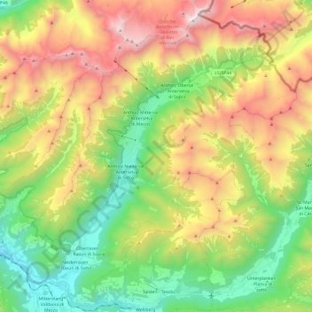
Name: Rasen-Antholz - Rasun-Anterselva topographic map, elevation, terrain.
Average elevation: 1,934 m
Minimum elevation: 934 m
Maximum elevation: 3,417 m
Other topographic maps
Click on a map to view its topography, its elevation and its terrain.
Antholzer See - Lago di Anterselva
Italy > Trentino-Alto Adige/Südtirol > South Tyrol > Rasen-Antholz - Rasun-Anterselva
Antholzer See - Lago di Anterselva, Rasen-Antholz - Rasun-Anterselva, Pustertal - Val Pusteria, South Tyrol, Trentino-Alto Adige/Südtirol, Italy
Average elevation: 1,890 m