
Travemünde topographic map
Interactive map
Click on the map to display elevation.
About this map
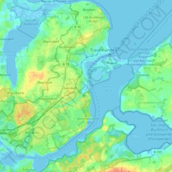
Name: Travemünde topographic map, elevation, terrain.
Location: Travemünde, Lübeck, Schleswig-Holstein, 23570, Germany (53.88519 10.80089 53.99389 10.96872)
Average elevation: 10 m
Minimum elevation: -4 m
Maximum elevation: 51 m
Other topographic maps
Click on a map to view its topography, its elevation and its terrain.
Lübeck
Germany > Schleswig-Holstein > Lübeck
Lübeck, Schleswig-Holstein, 23552, Germany
Average elevation: 29 m
Sankt Gertrud
Germany > Schleswig-Holstein > Lübeck > Marli
Sankt Gertrud, Marli, Lübeck, Schleswig-Holstein, 23566, Germany
Average elevation: 11 m