
North Shore Mountains topographic map
Interactive map
Click on the map to display elevation.
About this map
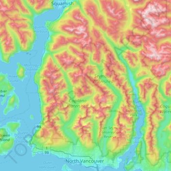
Name: North Shore Mountains topographic map, elevation, terrain.
Average elevation: 634 m
Minimum elevation: -2 m
Maximum elevation: 1,995 m
Other topographic maps
Click on a map to view its topography, its elevation and its terrain.
The West Lion
Canada > British Columbia > Electoral Area A
Hikers can climb up to the ridge between the East and West Lion peaks using either the Binkert Trail leading up from Lions Bay, or the Howe Sound Crest Trail. The Binkert Trail, named after Paul Binkert of the British Columbia Mountaineering Club, is one of the most popular in the Lower Mainland. Hiking to the…
Average elevation: 1,159 m