
Bryn Mawr topographic map
Interactive map
Click on the map to display elevation.
About this map
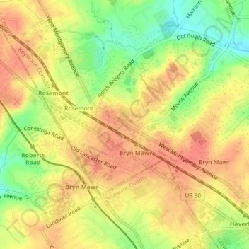
Name: Bryn Mawr topographic map, elevation, terrain.
Average elevation: 117 m
Minimum elevation: 84 m
Maximum elevation: 136 m
Other topographic maps
Click on a map to view its topography, its elevation and its terrain.
Ardmore
USA > Pennsylvania > Lower Merion Township
Ardmore, Simpson Road, Wynnewood, Lower Merion Township, Montgomery County, Pennsylvania, 19003, USA
Average elevation: 99 m
Dove Lake
USA > Pennsylvania > Lower Merion Township
Dove Lake, Dove Lake Road, Wynnewood, Lower Merion Township, Montgomery County, Pennsylvania, 19035, USA
Average elevation: 102 m