
Nyala topographic map
Interactive map
Click on the map to display elevation.
Nyala
When the United Kingdom conquered present-day Sudan, the British commander-in-chief met Sultan Adam Suleiman in 1932, seeking his advice for his knowledge of the best places in terms of availability of water sources and land topography in order to establish the British Administration Headquarters in Darfur. Sultan Adam Suleiman had chosen Nyala for that purpose.
About this map
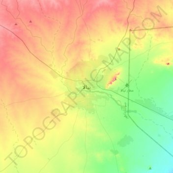
Name: Nyala topographic map, elevation, terrain.
Location: Nyala, South Darfur State, Sudan (11.89051 24.71951 12.21051 25.03951)
Average elevation: 677 m
Minimum elevation: 595 m
Maximum elevation: 782 m