
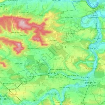
Sachsenheim topographic map
Interactive map
Click on the map to display elevation.
About this map
Name: Sachsenheim topographic map, elevation, terrain.
Average elevation: 258 m
Minimum elevation: 163 m
Maximum elevation: 475 m
Other topographic maps
Click on a map to view its topography, its elevation and its terrain.
Riet
Germany > Baden-Württemberg > Landkreis Ludwigsburg > Vaihingen an der Enz
Average elevation: 311 m
Hohenhaslach
Germany > Baden-Württemberg > Landkreis Ludwigsburg > Sachsenheim
Average elevation: 281 m
Nussdorf
Germany > Baden-Württemberg > Landkreis Ludwigsburg
The municipality (Gemeinde) of Eberdingen is located at the western extremity of the district of Ludwigsburg, in the German state of Baden-Württemberg, along its border with the districts of Böblingen and the Enz. Eberdingen is physically located in the basin of [de] the Neckar. Elevation above sea level in…
Average elevation: 321 m
Rielingshausen
Germany > Baden-Württemberg > Landkreis Ludwigsburg > Marbach am Neckar
Average elevation: 291 m
Ground Zero
Germany > Baden-Württemberg > Landkreis Ludwigsburg > Ludwigsburg
Average elevation: 304 m