
Make a donation
Gear up for your next adventure:
As an Amazon Associate, this site earns from qualifying purchases at no extra cost to you.
Bukit Kiara topographic map
Click on the map to display elevation.
Make a donation
Gear up for your next adventure:
As an Amazon Associate, this site earns from qualifying purchases at no extra cost to you.
About this map
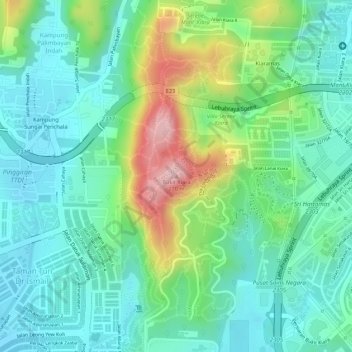
Name: Bukit Kiara topographic map, elevation, terrain.
Location: Bukit Kiara, Kuala Lumpur, 60000, Malaysia (3.15841 101.63595 3.15851 101.63605)
Average elevation: 106 m
Minimum elevation: 42 m
Maximum elevation: 249 m
Make a donation
Gear up for your next adventure:
As an Amazon Associate, this site earns from qualifying purchases at no extra cost to you.
Other topographic maps
Click on a map to view its topography, its elevation and its terrain.
Kiara Hills Federal Park Family Recreation Zone
Malaysia > Kuala Lumpur > Kuala Lumpur
Average elevation: 81 m
Make a donation
Gear up for your next adventure:
As an Amazon Associate, this site earns from qualifying purchases at no extra cost to you.
Batu Metropolitan Park
Malaysia > Kuala Lumpur > Kuala Lumpur > Kampung Sri Batu
Average elevation: 47 m
Make a donation
Gear up for your next adventure:
As an Amazon Associate, this site earns from qualifying purchases at no extra cost to you.
Make a donation
Gear up for your next adventure:
As an Amazon Associate, this site earns from qualifying purchases at no extra cost to you.
KLCC Park
Malaysia > Kuala Lumpur > Kuala Lumpur
The park was designed to showcase a heritage of tropical greenery by integrating man's creation with nature. The park itself contrasts as a calm environment in the midst of the hustle and bustle of the city. The park features many combinations of man-made design such as cements, water features and also natural…
Average elevation: 46 m
Make a donation
Gear up for your next adventure:
As an Amazon Associate, this site earns from qualifying purchases at no extra cost to you.