
Lakeside Park topographic map
Interactive map
Click on the map to display elevation.
About this map
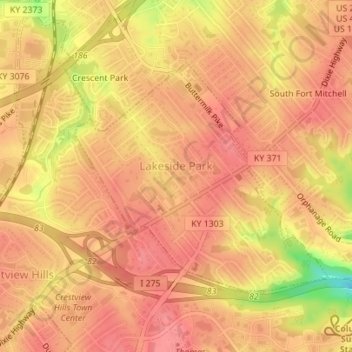
Name: Lakeside Park topographic map, elevation, terrain.
Location: Lakeside Park, Kenton County, Kentucky, 41017, United States (39.02600 -84.57911 39.04356 -84.55411)
Average elevation: 255 m
Minimum elevation: 199 m
Maximum elevation: 273 m
Other topographic maps
Click on a map to view its topography, its elevation and its terrain.
Morning View
United States > Kentucky > Kenton County
Morning View, Kenton County, Kentucky, 41063, United States
Average elevation: 192 m
Villa Hills
United States > Kentucky > Kenton County
Villa Hills, Kenton County, Kentucky, United States
Average elevation: 224 m
Taylor Mill
United States > Kentucky > Kenton County
Taylor Mill, Kenton County, Kentucky, 41015, United States
Average elevation: 211 m
Covington
United States > Kentucky > Kenton County > Covington
Covington, Kenton County, Kentucky, United States
Average elevation: 215 m
Sunny Acres
United States > Kentucky > Kenton County > Taylor Mill > Sunny Acres
Sunny Acres, Taylor Mill, Kenton County, Kentucky, 41015, United States
Average elevation: 216 m