
Carrickfergus Castle topographic map
Interactive map
Click on the map to display elevation.
About this map
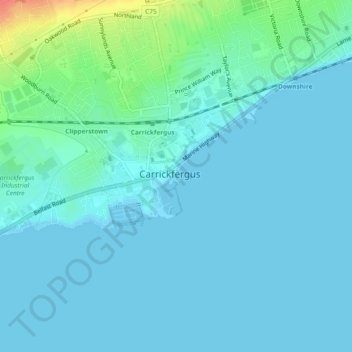
Name: Carrickfergus Castle topographic map, elevation, terrain.
Average elevation: 8 m
Minimum elevation: 0 m
Maximum elevation: 52 m
Other topographic maps
Click on a map to view its topography, its elevation and its terrain.
Woodburn
United Kingdom > Northern Ireland > Carrickfergus
Woodburn, Eden ED, Carrickfergus, County Antrim, Northern Ireland, BT38 8QB, United Kingdom
Average elevation: 87 m