
Admirals Park (Rainsford Lane) topographic map
Interactive map
Click on the map to display elevation.
About this map
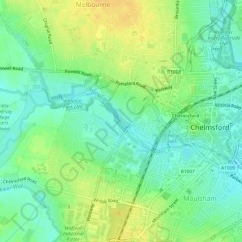
Name: Admirals Park (Rainsford Lane) topographic map, elevation, terrain.
Average elevation: 34 m
Minimum elevation: 22 m
Maximum elevation: 49 m
Essex trails, hiking, mountain biking, running and outdoor activities
Other topographic maps
Click on a map to view its topography, its elevation and its terrain.
Hanningfield Reservoir
United Kingdom > England > Essex > Chelmsford > South Hanningfield
Average elevation: 56 m