
Nantenbach topographic map
Interactive map
Click on the map to display elevation.
About this map
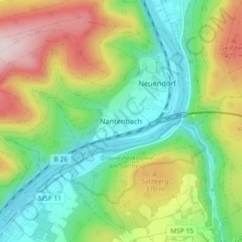
Name: Nantenbach topographic map, elevation, terrain.
Average elevation: 280 m
Minimum elevation: 145 m
Maximum elevation: 511 m
Other topographic maps
Click on a map to view its topography, its elevation and its terrain.
Marktheidenfeld
Germany > Bavaria > Landkreis Main-Spessart > Marktheidenfeld
Average elevation: 211 m
Lohr am Main
Germany > Bavaria > Landkreis Main-Spessart
The Main river valley is steep with an elevation change from 160 m above sea level at Gemünden dropping to 100 m above sea level at Hanau. The river Main in its natural state is a fast-moving stream unsuitable for shipping. In the 19th century the river was tamed and a system of dams and locks is now part of…
Average elevation: 336 m