
Bảo Lâm District topographic map
Interactive map
Click on the map to display elevation.
About this map
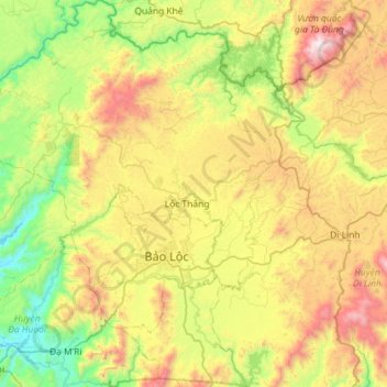
Name: Bảo Lâm District topographic map, elevation, terrain.
Location: Bảo Lâm District, Lâm Đồng Province, Vietnam (11.35962 107.48372 11.92229 107.96792)
Average elevation: 787 m
Minimum elevation: 143 m
Maximum elevation: 1,943 m
Other topographic maps
Click on a map to view its topography, its elevation and its terrain.
Dalat
Vietnam > Lâm Đồng Province > Dalat
Dalat, Đà Lạt District, Lâm Đồng Province, 6700, Vietnam
Average elevation: 1,360 m
Phường 10
Vietnam > Lâm Đồng Province > Da Lat City
Phường 10, Da Lat City, Lâm Đồng Province, Vietnam
Average elevation: 1,399 m
Đơn Dương District
Đơn Dương District, Lâm Đồng Province, Vietnam
Average elevation: 1,078 m
Bidoup Núi Bà National Park
Vietnam > Lâm Đồng Province > Lạc Dương District
Bidoup Núi Bà National Park, Lạc Dương District, Lâm Đồng Province, 66200, Vietnam
Average elevation: 1,311 m
Xã Đại Lào
Vietnam > Lâm Đồng Province > Bảo Lộc City
Xã Đại Lào, Bảo Lộc City, Lâm Đồng Province, Vietnam
Average elevation: 836 m
Liên Nghĩa
Vietnam > Lâm Đồng Province > Đức Trọng District
Liên Nghĩa, Đức Trọng District, Lâm Đồng Province, Vietnam
Average elevation: 952 m
Khu Phố Sáu
Vietnam > Lâm Đồng Province > Đạ Huoai District
Khu Phố Sáu, Đạ Huoai District, Lâm Đồng Province, Vietnam
Average elevation: 438 m
Nam Ban
Vietnam > Lâm Đồng Province > Lâm Hà District
Nam Ban, Lâm Hà District, Lâm Đồng Province, Vietnam
Average elevation: 1,013 m
Clearest Water in Vietnam
Vietnam > Lâm Đồng Province > Bảo Lâm District > Bảo Lộc
Clearest Water in Vietnam, Phùng Hưng, Bảo Lộc, Bảo Lâm District, Lâm Đồng Province, Vietnam
Average elevation: 858 m
Bản Đơng Mang
Vietnam > Lâm Đồng Province > Lạc Dương District > Bản Đơng Mang
Bản Đơng Mang, Lạc Dương District, Lâm Đồng Province, Vietnam
Average elevation: 1,597 m
Lâm Hà District
Lâm Hà District, Lâm Đồng Province, Vietnam
Average elevation: 1,112 m
Than Tho Lake
Vietnam > Lâm Đồng Province > Dalat
Than Tho Lake, Ho Xuan Huong, Dalat, Đà Lạt District, Lâm Đồng Province, 61000, Vietnam
Average elevation: 1,521 m
Lạc Dương District
Lạc Dương District, Lâm Đồng Province, 66200, Vietnam
Average elevation: 1,322 m