
Casale Monferrato topographic map
Interactive map
Click on the map to display elevation.
Casale Monferrato
At the southeast corner of the piazza is the elegant Baroque church of Santa Maria delle Grazie, better known by its earlier designation of Santa Caterina. A masterwork of Giovanni Battista Scapitta, completed after his death by Giacomo Zanetti, it is marked by an elliptical cupola, and a façade curvilinear both in plan and elevation.
About this map
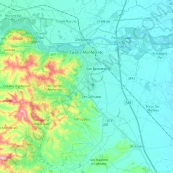
Name: Casale Monferrato topographic map, elevation, terrain.
Location: Casale Monferrato, Alessandria, Piedmont, 15033, Italy (45.04102 8.35945 45.17566 8.55704)
Average elevation: 142 m
Minimum elevation: 97 m
Maximum elevation: 338 m
Other topographic maps
Click on a map to view its topography, its elevation and its terrain.