
Herford topographic map
Interactive map
Click on the map to display elevation.
About this map
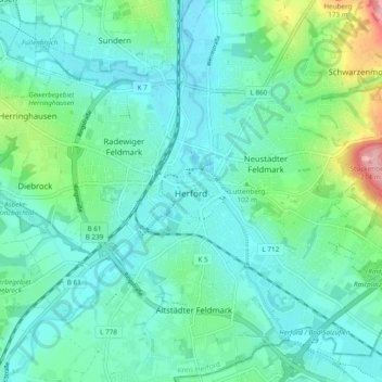
Name: Herford topographic map, elevation, terrain.
Location: Herford, Kreis Herford, North Rhine-Westphalia, Germany (52.08628 8.63632 52.14486 8.72671)
Average elevation: 91 m
Minimum elevation: 59 m
Maximum elevation: 217 m
Other topographic maps
Click on a map to view its topography, its elevation and its terrain.
Kirchlengern
Germany > North Rhine-Westphalia > Kreis Herford
Kirchlengern, Kreis Herford, North Rhine-Westphalia, Germany
Average elevation: 80 m
Herford
Germany > North Rhine-Westphalia > Kreis Herford
Herford, Kreis Herford, North Rhine-Westphalia, Germany
Average elevation: 107 m
Spenge
Germany > North Rhine-Westphalia > Kreis Herford
Spenge, Kreis Herford, North Rhine-Westphalia, 32139, Germany
Average elevation: 105 m
Ennigloh
Germany > North Rhine-Westphalia > Kreis Herford > Bünde > Gewinghausen
Ennigloh, Gewinghausen, Bünde, Kreis Herford, North Rhine-Westphalia, 32257, Germany
Average elevation: 77 m