
Ratby topographic map
Interactive map
Click on the map to display elevation.
About this map
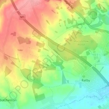
Name: Ratby topographic map, elevation, terrain.
Average elevation: 118 m
Minimum elevation: 74 m
Maximum elevation: 168 m
Other topographic maps
Click on a map to view its topography, its elevation and its terrain.
Barwell
United Kingdom > England > Hinckley and Bosworth > Barwell
Barwell, Hinckley and Bosworth, Leicestershire, East Midlands, England, LE9 8DD, United Kingdom
Average elevation: 111 m
Bagworth & Thornton
United Kingdom > England > Hinckley and Bosworth
Bagworth & Thornton, Hinckley and Bosworth, Leicestershire, East Midlands, England, United Kingdom
Average elevation: 140 m
Peckleton
United Kingdom > England > Hinckley and Bosworth
Peckleton, Hinckley and Bosworth, Leicestershire, East Midlands, England, United Kingdom
Average elevation: 113 m
Rothley Brook
United Kingdom > England > Hinckley and Bosworth
Rothley Brook, Hinckley and Bosworth, Leicestershire, East Midlands, England, LE9 2BG, United Kingdom
Average elevation: 99 m
Tweed River
United Kingdom > England > Hinckley and Bosworth
Tweed River, Hinckley and Bosworth, Leicestershire, East Midlands, England, CV13 6DS, United Kingdom
Average elevation: 98 m